
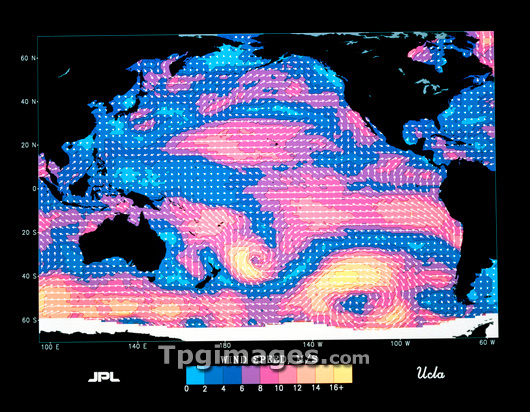
Satellite map of wind speed and direction over the Pacific Ocean. The arrows represent wind direction & the colours wind speed. Blue indicates wind speeds of 3-14 kilometres per hour (kph), gray speeds of 15-21 kph, red speeds of 22-56 kph, and yellow speeds of 57-70 kph. Note the high wind speeds near storms in the South Pacific and east of New Zealand. The image was derived from data obtained in 1978 by the scatterometer instrument on NASA's Seasat satellite; the data was processed in 1989 at NASA's Jet Propulsion Laboratory (JPL) in Pasadena, California.
| px | px | dpi | = | cm | x | cm | = | MB |
Details
Creative#:
TOP03207220
Source:
達志影像
Authorization Type:
RM
Release Information:
須由TPG 完整授權
Model Release:
N/A
Property Release:
N/A
Right to Privacy:
No
Same folder images:
 Loading