
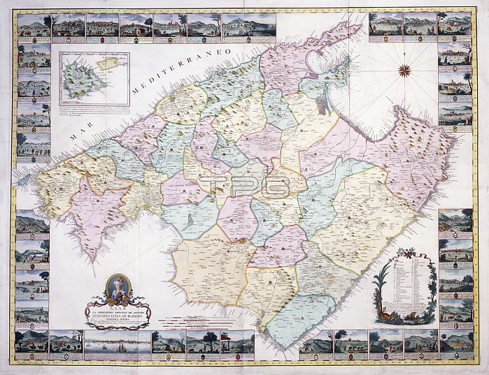
986325 Map of the Island of Mallorca, 1785 (hand-coloured engraving) by Spanish School, (18th century); 121x160 cm; Private Collection; (add.info.: Map of the Island of Mallorca; Mapa de la Isla de Mallorca, by Joseph and Antonio Despuig y Dameto Muntaner. Spanish School, (18th century). Hand-coloured engraving. Printed in Mallorca, 1785. 121 x 160cm.); Photo 穢 Christie\'s Images.
| px | px | dpi | = | cm | x | cm | = | MB |
Details
Creative#:
TOP27249456
Source:
達志影像
Authorization Type:
RM
Release Information:
須由TPG 完整授權
Model Release:
No
Property Release:
No
Right to Privacy:
No
Same folder images:
travelingclose-uphandcoloured1780snopersonspainprintrecreationhand-tintedholidayleisurecloseuplateeighteenthcenturyhandcoloringnavigationalequipmentinsetmajorcatraveleighteenthcenturyspanishschoolcloseup18thcenturysightseeingcolorhandcoloredleisurelyno-onerecreationalhand-coloredholidaysprintshandcolouredislandlate18thcenturygeographicmapgeographyfreetimenobodyislehand-colouringnopeoplehand-colouredhandcoloredvacationtravellingengravedtourismengravingmallorcacoloureuropehandcolouring1785EngravingMzengravingclose-uphandcoloured1780snopersonspainprintrecreationhand-tintedholidayleisurecloseuplateeighteenthcenturyhandcoloringnavigationalequipmentinsetmajorcatraveleighteenthcenturyspanishschoolcloseup18thcenturysightseeingcolorhandcoloredleisurelyno-onerecreationalhand-coloredholidaysprintshandcolouredislandlate18thcenturygeographicmapgeographyfreetimenobodyislehand-colouringnopeoplehand-colouredhandcoloredvacationtravellingengravedtourismengravingmallorcacoloureuropehandcolouring1785
1780s1780s1785178518th18th18th18thEngravingMzengravingcenturycenturycenturycenturycenturycenturycenturycenturyclosecloseclose-upclose-upcloseupcloseupcolorcolorcoloredcoloredcoloringcoloringcolourcolourcolouredcolouredcolouringcolouringeighteentheighteentheighteentheighteenthengravedengravedengravingengravingequipmentequipmenteuropeeuropefreetimefreetimegeographicgeographicgeographygeographyhandhandhandhandhandhandhandhandhand-coloredhand-coloredhand-colouredhand-colouredhand-colouringhand-colouringhand-tintedhand-tintedhandcoloredhandcoloredhandcolouredhandcolouredholidayholidayholidaysholidaysinsetinsetislandislandisleislelatelatelatelateleisureleisureleisurelyleisurelymajorcamajorcamallorcamallorcamapmapnavigationalnavigationalnonononono-oneno-onenobodynobodypeoplepeoplepersonpersonprintprintprintsprintsrecreationrecreationrecreationalrecreationalschoolschoolsightseeingsightseeingspainspainspanishspanishtourismtourismtraveltraveltravelingtravellingtravellingupupvacationvacation
 Loading