
filter
-
Brand
- By Category
- Direction
- Date Range
79Events
Pictures
Events

Editorial Southport incident
- 2024-07-30
- 5

Editorial Shutterstock Portrait Studio, 2024 Tribeca Festival - Day 3, New York, USA - 08 Jun 2024
- 2024-06-09
- 7
Editorial Shutterstock Portrait Studio, 2024 Tribeca Festival - Day 3, New York, USA - 08 Jun 2024
- 2023-06-16
- 1
Editorial Shutterstock Portrait Studio, 2024 Tribeca Festival - Day 3, New York, USA - 08 Jun 2024
- 2023-06-15
- 1
Editorial Shutterstock Portrait Studio, 2024 Tribeca Festival - Day 3, New York, USA - 08 Jun 2024
- 2023-06-15
- 1

Editorial Shutterstock Portrait Studio, 2024 Tribeca Festival - Day 3, New York, USA - 08 Jun 2024
- 2023-06-07
- 1
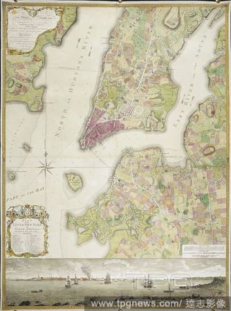
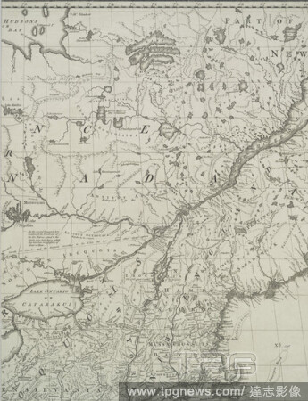
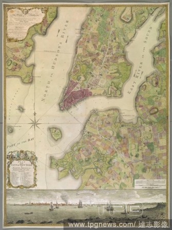
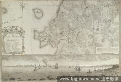
Editorial Plan of the City of New York, in North America: surveyed in the years 1766 & 1767. Plan of the City of New York, in North America: surveyed in the years 1766 & 1767. To His Excellency Sir Henry Moore, Bart ... This Plan of the City of New York and its ...
- 2022-12-24
- 1

Editorial An 18th century plan of the city of New York. PLAN of the CITY of NEW YORK, in North America : Surveyed in the Years 1766 & 1767 / B. Ratzer, Lieut.t in His Majestys 60th or Royal American Reg.t. [London] : [Thomas Kitchin], [about 1770.]. 1 map on 3 s...
- 2022-12-24
- 1
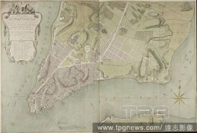
Editorial A plan of the city of New York. To His Excellency S:r Henry Moore, Bar.t Captain General and Governour in Chief & over the Province of NEW YORK & the Territories depending thereon in AMERICA Chancellor & Vice Admiral of the Same. This PLAN of the CITY ...
- 2022-12-24
- 1
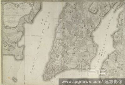
Editorial Plan of the City of New York ... surveyed in the years 1766 & 1767... A South West View of the City of New York, taken from the Government Island. . Plan of the City of New York, in North America: surveyed in the years 1766 & 1767. To His Excellency Si...
- 2022-12-24
- 1

Editorial Plan of the City of New York, in North America: surveyed in the years 1766 & 1767... A South West View of the City of New York, taken from the Government Island. . Plan of the City of New York, in North America: surveyed in the years 1766 & 1767. To Hi...
- 2022-12-24
- 1
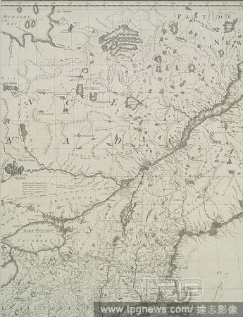
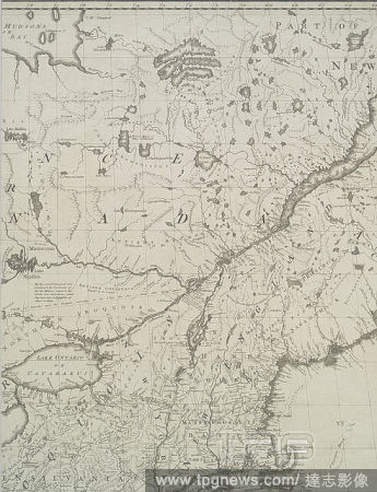
Editorial A map of the British and French dominions in North America : with the roads, distances, limits, and extent of the settlements, humbly inscribed to the Right Honourable the Earl of Halifax, and the other Right Honourable the Lords Commissioners for Trad...
- 2022-12-24
- 1

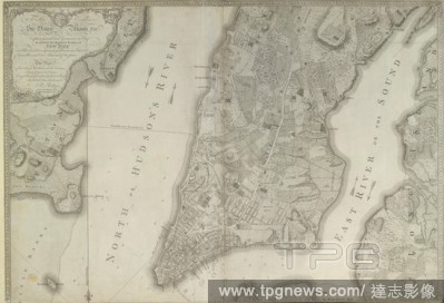
Editorial Plan of the city of New York in North America : surveyed in the years 1766 & 1767, still image, Maps, 1776-01-12, Faden, William (1750?-1836), Kitchin, Thomas (d. 1784), Ratzer, Bernard.
- 2022-12-24
- 1

Editorial St. George and the Dragon.
- 2022-07-21
- 1

Editorial "The Prettiest Doll in the World".
- 2022-07-21
- 1
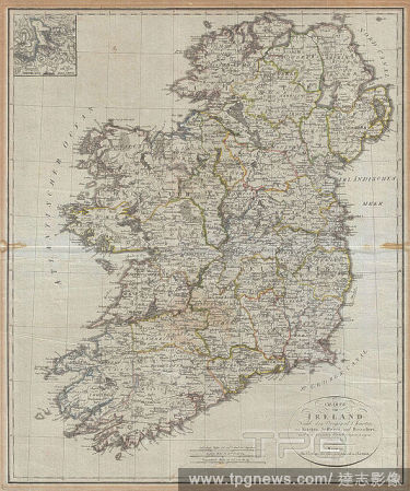
Editorial 1804, Jeffreys and Kitchin Map of Ireland.
- 2022-01-18
- 1

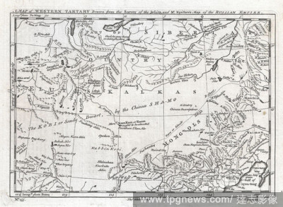
Editorial 1747, Kitchin Map of Central Asia and the Gobi Desert.
- 2022-01-18
- 1

Editorial 1773, Kitchin Map of the Country 30 Miles around London, England.
- 2022-01-18
- 1
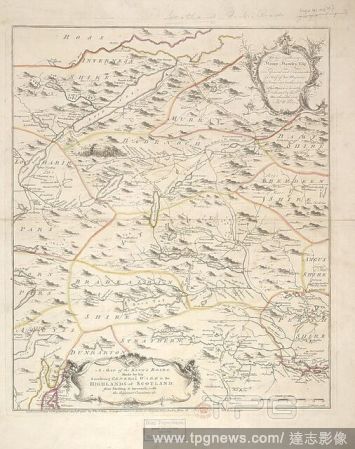
Editorial A Map of the King's Roads in the Highlands of Scotland: from Stirling to Inverness. A Map of the King's Roads, made by his Excellency General Wade in the Highlands of Scotland: from Stirling to Inverness, with the adjacent countries &c. T. Kitchin scul...
- 2022-01-18
- 1
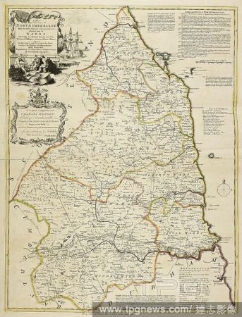
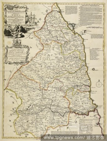
Editorial A map of Northumberland. A new and improved Map of Northumberland. London, 1750. Source: Maps K.Top.32.41. Language: English.
- 2022-01-18
- 1
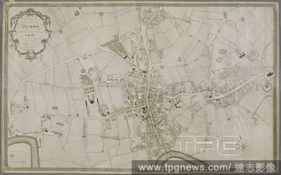
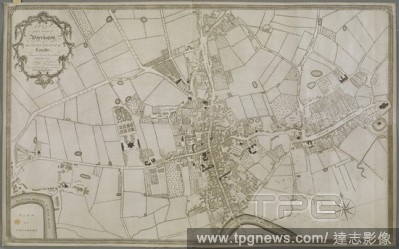
Editorial A plan of Warrington. A PLAN, of the Town of Warrington: in the COUNTY PALATINE of Lancaster. : From an Accurate Survey Taken in the Year 1772. [London?] : [Thomas Kitchin] Publish'd as the Act Directs 1st. September 1773, [1773.]. Source: Maps K.Top.1...
- 2022-01-18
- 1

Editorial Plan of the City of New York ... surveyed in the years 1766 & 1767... A South West View of the City of New York, taken from the Government Island. . Plan of the City of New York, in North America: surveyed in the years 1766 & 1767. To His Excellency Si...
- 2022-01-18
- 1

Editorial Plan of the City of New York, in North America: surveyed in the years 1766 & 1767... A South West View of the City of New York, taken from the Government Island. . Plan of the City of New York, in North America: surveyed in the years 1766 & 1767. To Hi...
- 2022-01-18
- 1

Editorial A map of Switzerland. Carte de Suisse ... Dresse?e rectifie?e et augmente?e ... [London], 1760. Source: Maps K.Top.85.24. Language: French.
- 2022-01-18
- 1

Editorial Plan of the City of New York, in North America: surveyed in the years 1766 & 1767. Plan of the City of New York, in North America: surveyed in the years 1766 & 1767. To His Excellency Sir Henry Moore, Bart ... This Plan of the City of New York and its ...
- 2022-01-18
- 1

Editorial An 18th century plan of the city of New York. PLAN of the CITY of NEW YORK, in North America : Surveyed in the Years 1766 & 1767 / B. Ratzer, Lieut.t in His Majestys 60th or Royal American Reg.t. [London] : [Thomas Kitchin], [about 1770.]. 1 map on 3 s...
- 2022-01-18
- 1
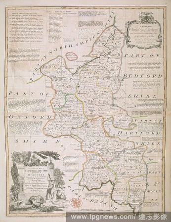
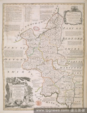
Editorial A map of Buckinghamshire. The Large English Atlas; or, a new set of maps of all the Counties in England and Wales ... By Emanuel Bowen and Thomas Kitchin. London : T. Bowles ... J. Bowles & Son ... J. Tinney ... & R. Sayer, [1760]. Source: Maps C.10.d....
- 2022-01-18
- 2

Editorial An illustration of the city of Calcutta in 1756. Ships of the fleet in the harbour. Buildings on the shore. A commercial trade port. . History of the Military Transactions of the British Nation in Indostan from the year 1745. London England 1803. Calcu...
- 2022-01-18
- 1

Editorial Big Feastival 2021
- 2021-08-31
- 9

Editorial Xie Kitchin. Dated: 1869. Dimensions: sheet: 10.7 x 13.7 cm (4 3/16 x 5 3/8 in.). Medium: albumen print.
- 2021-06-04
- 1
Editorial A map of the British and French dominions in North America : with the roads, distances, limits, and extent of the settlements, humbly inscribed to the Right Honourable the Earl of Halifax, and the other Right Honourable the Lords Commissioners for Trad...
- 2021-04-07
- 1

Editorial Plan of the city of New York in North America : surveyed in the years 1766 & 1767, still image, Maps, 1776-01-12, Faden, William (1750?-1836), Kitchin, Thomas (d. 1784), Ratzer, Bernard.
- 2021-04-07
- 1
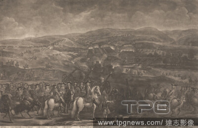
Editorial Battle of the Boyne, July 1st 1690, Thomas Kitchin, 17191784, British, after Jan Wyck, ca. 16451700, Dutch, active in Britain (from ca. 1664), undated, Mezzotint on moderately thick, slightly textured, cream, laid paper, Sheet: 17 3/4 ? 27 5/8 inches (...
- 2021-02-21
- 1

Editorial A View of the New Tower and part of the Great Kitchin Window of Arundel Castle, Sussex (published by J. Sewell); page 13 (Volume One), Samuel Rawle, 17711860, British, after John Nixon, ca. 17601818, British, 1802, Engraving.
- 2021-02-21
- 1
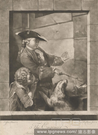
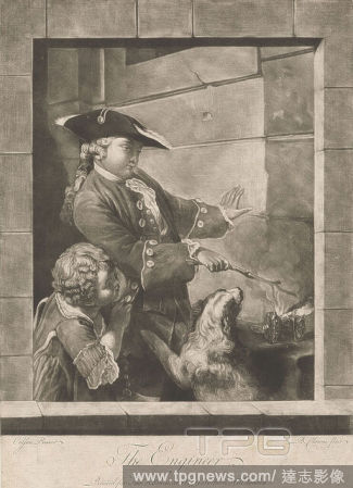
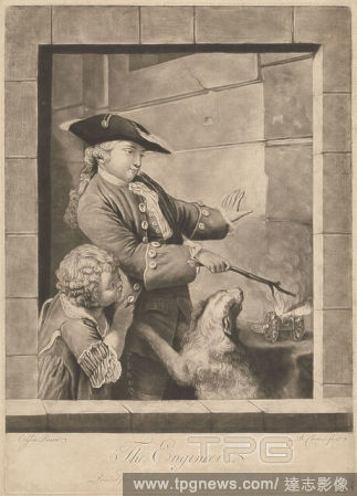
Editorial The Engineer, Print made by Butler Clowes, active 1768, died 1782, British, after Jean Fran?ois Gille Colson, 17331803, French, Published by Thomas Kitchin, 17191784, British, ca. 1770, Mezzotint on moderately thick, slightly textured, beige laid paper...
- 2021-02-21
- 1
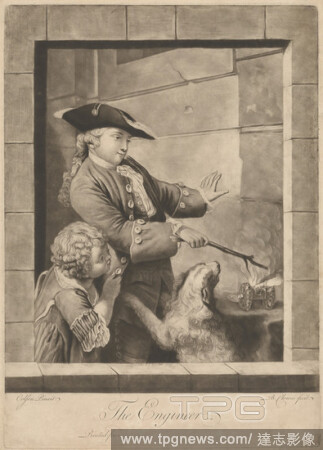
Editorial The Engineer, Print made by Butler Clowes, active 1768, died 1782, British, after Jean Fran?ois Gille Colson, 17331803, French, Published by Thomas Kitchin, 17191784, British, ca. 1770, Mezzotint on moderately thick, slightly textured, beige laid paper...
- 2021-02-21
- 1

Editorial Thomas Rowlandson, Kitchin Stuff, Thomas Rowlandson (British, London 17571827 London), November 1, 1810, Hand-colored etching, Sheet: 12 5/8 ? 8 13/16 in. (32.1 ? 22.4 cm), Prints.
- 2021-02-19
- 1

Editorial Plan of the City of New York, in North America: surveyed in the years 1766 & 1767. Plan of the City of New York, in North America: surveyed in the years 1766 & 1767. To His Excellency Sir Henry Moore, Bart ... This Plan of the City of New York and its ...
- 2020-12-04
- 1

Editorial An 18th century plan of the city of New York. PLAN of the CITY of NEW YORK, in North America : Surveyed in the Years 1766 & 1767 / B. Ratzer, Lieut.t in His Majestys 60th or Royal American Reg.t. [London] : [Thomas Kitchin], [about 1770.]. 1 map on 3 s...
- 2020-12-04
- 1

Editorial A plan of the city of New York. To His Excellency S:r Henry Moore, Bar.t Captain General and Governour in Chief & over the Province of NEW YORK & the Territories depending thereon in AMERICA Chancellor & Vice Admiral of the Same. This PLAN of the CITY ...
- 2020-12-04
- 1

Editorial Plan of the City of New York ... surveyed in the years 1766 & 1767... A South West View of the City of New York, taken from the Government Island. . Plan of the City of New York, in North America: surveyed in the years 1766 & 1767. To His Excellency Si...
- 2020-12-02
- 1

Editorial Plan of the City of New York, in North America: surveyed in the years 1766 & 1767... A South West View of the City of New York, taken from the Government Island. . Plan of the City of New York, in North America: surveyed in the years 1766 & 1767. To Hi...
- 2020-12-02
- 1

Editorial An illustration of the city of Calcutta in 1756. Ships of the fleet in the harbour. Buildings on the shore. A commercial trade port. . History of the Military Transactions of the British Nation in Indostan from the year 1745. London England 1803. Calcu...
- 2020-12-01
- 1

Editorial An illustration of the city of Calcutta in 1756. Ships of the fleet in the harbour. Buildings on the shore. A commercial trade port. . History of the Military Transactions of the British Nation in Indostan from the year 1745. London England 1803. Calcu...
- 2020-09-28
- 1

Editorial "The Prettiest Doll in the World".
- 2020-09-11
- 1

Editorial Xie Kitchin as "A Chinaman". Date/Period: 1873. Gum platinum print. Width: 18.5 cm. Height: 21.4 cm (Image).
- 2020-07-29
- 1

Editorial Xie Kitchin. Dated: 1869. Dimensions: sheet: 10.7 x 13.7 cm (4 3/16 x 5 3/8 in.). Medium: albumen print.
- 2020-03-02
- 1
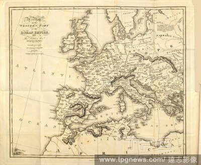
Editorial Map of the western part of the Roman Empire, Map of the Western Territory of the Roman Empire, signed: by Tho., Kitchin Sen, Taf. 2, according to p. XXXI, Kitchin, Thomas Senior (by), Edward Gibbon: The history of the decline and fall of the Roman Empi...
- 2020-01-15
- 1
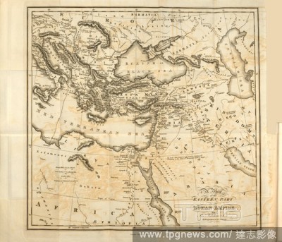
Editorial Map of the eastern part of the Roman Empire, Map of the Eastern Territory of the Roman Empire, signed: By Tho., Kitchin Sen, Taf. 1, according to p. 16, Kitchin, Thomas Senior (by), Edward Gibbon: The history of the decline and fall of the Roman Empire...
- 2020-01-15
- 1

Editorial "The Prettiest Doll in the World".
- 2019-10-28
- 1

Editorial St. George and the Dragon.
- 2019-04-16
- 1

Editorial "The Prettiest Doll in the World".
- 2019-02-15
- 1

Editorial St. George and the Dragon.
- 2019-02-11
- 1

Editorial Xie Kitchin as "A Chinaman". Date/Period: 1873. Gum platinum print. Width: 18.5 cm. Height: 21.4 cm (Image).
- 2019-02-01
- 1

Editorial St. George and the Dragon.
- 2019-02-01
- 1

Editorial "The Prettiest Doll in the World".
- 2019-02-01
- 1

Editorial Covering homelessness is a passion for editor of underground paper
- 2019-01-25
- 2

Editorial 1804, Jeffreys and Kitchin Map of Ireland.
- 2019-01-23
- 1
Editorial 1747, Kitchin Map of Central Asia and the Gobi Desert.
- 2019-01-23
- 1

Editorial 1773, Kitchin Map of the Country 30 Miles around London, England.
- 2019-01-23
- 1

Editorial Plan of the City of New York, in North America: surveyed in the years 1766 & 1767. Plan of the City of New York, in North America: surveyed in the years 1766 & 1767. To His Excellency Sir Henry Moore, Bart ... This Plan of the City of New York and its ...
- 2018-12-06
- 1

Editorial A Map of the King's Roads in the Highlands of Scotland: from Stirling to Inverness. A Map of the King's Roads, made by his Excellency General Wade in the Highlands of Scotland: from Stirling to Inverness, with the adjacent countries &c. T. Kitchin scul...
- 2018-12-06
- 1
Editorial A map of Northumberland. A new and improved Map of Northumberland. London, 1750. Source: Maps K.Top.32.41. Language: English.
- 2018-12-06
- 1
Editorial A plan of Warrington. A PLAN, of the Town of Warrington: in the COUNTY PALATINE of Lancaster. : From an Accurate Survey Taken in the Year 1772. [London?] : [Thomas Kitchin] Publish'd as the Act Directs 1st. September 1773, [1773.]. Source: Maps K.Top.1...
- 2018-12-06
- 1
Editorial An 18th century plan of the city of New York. PLAN of the CITY of NEW YORK, in North America : Surveyed in the Years 1766 & 1767 / B. Ratzer, Lieut.t in His Majestys 60th or Royal American Reg.t. [London] : [Thomas Kitchin], [about 1770.]. 1 map on 3 s...
- 2018-12-06
- 1
Editorial A map of Buckinghamshire. The Large English Atlas; or, a new set of maps of all the Counties in England and Wales ... By Emanuel Bowen and Thomas Kitchin. London : T. Bowles ... J. Bowles & Son ... J. Tinney ... & R. Sayer, [1760]. Source: Maps C.10.d....
- 2018-12-06
- 2
Editorial Plan of the City of New York ... surveyed in the years 1766 & 1767... A South West View of the City of New York, taken from the Government Island. . Plan of the City of New York, in North America: surveyed in the years 1766 & 1767. To His Excellency Si...
- 2018-12-06
- 1
Editorial Plan of the City of New York, in North America: surveyed in the years 1766 & 1767... A South West View of the City of New York, taken from the Government Island. . Plan of the City of New York, in North America: surveyed in the years 1766 & 1767. To Hi...
- 2018-12-06
- 1

Editorial A map of Switzerland. Carte de Suisse ... Dresse?e rectifie?e et augmente?e ... [London], 1760. Source: Maps K.Top.85.24. Language: French.
- 2018-12-06
- 1
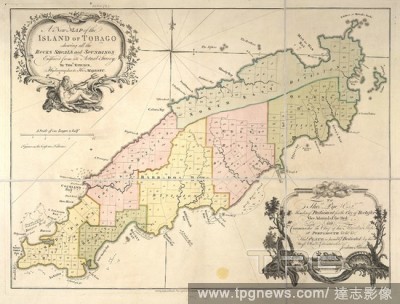
Editorial Tobago. A New Map of the Island of Tobago ... Engraved fro. London : J. Rhodes & T. Kitchin, [1760]. Source: Maps.*82510.(8),. Language: English.
- 2018-12-06
- 1

Editorial An illustration of the city of Calcutta in 1756. Ships of the fleet in the harbour. Buildings on the shore. A commercial trade port. . History of the Military Transactions of the British Nation in Indostan from the year 1745. London England 1803. Calcu...
- 2018-12-06
- 1

Editorial Xie Kitchin as "A Chinaman". Date/Period: 1873. Gum platinum print. Width: 18.5 cm. Height: 21.4 cm (Image).
- 2018-10-11
- 1

Editorial Xie Kitchin. Dated: 1869. Dimensions: sheet: 10.7 x 13.7 cm (4 3/16 x 5 3/8 in.). Medium: albumen print.
- 2018-09-18
- 1

Editorial St. George and the Dragon.
- 2018-08-06
- 1

Editorial "The Prettiest Doll in the World".
- 2018-08-06
- 1
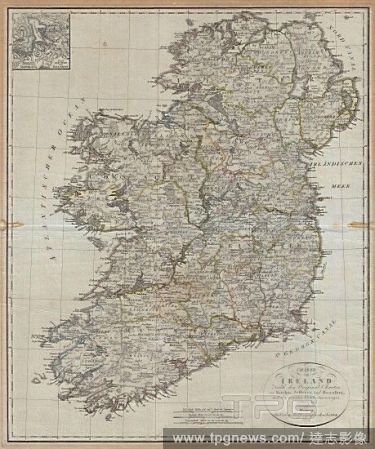
Editorial 1804, Jeffreys and Kitchin Map of Ireland.
- 2018-08-03
- 1
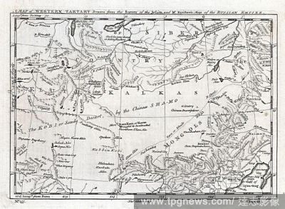
Editorial 1747, Kitchin Map of Central Asia and the Gobi Desert.
- 2018-08-03
- 1

Editorial 1773, Kitchin Map of the Country 30 Miles around London, England.
- 2018-08-03
- 1
 Loading